|
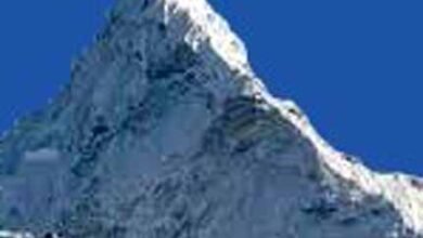
1. Which river divides the peninsular plateau into two parts? = Narmada River. 2. When is the longest day in Australia? = 22 December. 3. When is the longest day in India? = 21 June. 4. When is the shortest day in India? = 22 December. 5. When are day and night equal in India? = 21 March and 23 September. 6. Strong westerly winds blowing near 40° latitude in the southern hemisphere are called? = Roaring Chalisa. 7. The cold and strong wind that runs in the northern hemisphere, which goes from the sub-pole to the polar region, is called? = Naur-Easter. 8. Tropical evergreen forests are most commonly found in? = Biodiversity. 9. What plants are in the temperate deciduous forest? = Oak, maple, beech, hickory and chestnut. 10. What is a cyclone? = Cyclones are large rotating tropical storms caused by winds blowing around a central area of low atmospheric pressure. 11. What is Willy-Willies? = Tropical storm in Australia. 12. What is the southernmost point of India called? = Indira Point. 13. Fossils of flora and fauna are found in which type of rocks? = Sedimentary rock. 14. How much of the world lives on the plateaus? = 09 per cent. 15. Where is the plateau of Tibet located? = It is a large, high plateau located in Central Asia. 16. Which Strait is called the key to the Mediterranean Sea? = Gibraltar Water Treaty. 17. Which country is the Loess Plateau located in? = China. 18. Where is the Vindhya plateau situated? = India. 19. What is the Pat plateau of Ranchi? = Raised pennyplane. 20. Where is the Drakensberg Mountain located? = On the east coast of South Africa. 21. Where is the Telegraphic Plateau located? = North Atlantic Ocean. 22. Where is the Mysore Plateau located? = America. 23. Name the highest peak of the Andes mountain range? = Mount Aconcagua. 24. The world’s highest peak? = Mount Everest. 25. What is the height of Mount Everest? = 8848 m. 26. What is the height of Kangchenjunga, the main peak of the Himalayas? = 8,848 metres. 27. Where is the Colombian Plateau? = Spread across parts of the US states of Washington, Oregon, and Idaho. 28. How many continents does the border of the Mediterranean Sea touch? = To the north by Western Europe, Southern Europe and Anatolia, to the south by North Africa, and the east by the Levant. 29. The areas of grass similar to savanna in Venezuela, Colombia and Brazil are called? = Lanoz and Pampaz. 30. The hot water current flowing from north to south near the Piru coast is called? = Humboldt River. ========== ========== =========== भूगोल से संबंधित– 185.
1. प्रायद्वीपीय पठार को दो भागों में विभाजित करने वाली कौन-सी नदी है? = नर्मदा नदी.
3. भारत मे सबसे बड़ा दिन कब होता है? = 21 जून. 4. भारत मे सबसे छोटी दिन कब होता है? = 22 दिसम्बर. 5. भारत मे दिन-रात कब बराबर होते हैं? = 21 मार्च और 23 सितंबर. 6. दक्षिणी गोलार्द्ध में 40° अक्षांश के पास चलने वाली तेज पछुआ हवाएं कहलाती है? = दहाड़ता चालीसा. 7. उत्तरी गोलार्द्ध में चलने वाली शीत और तेज वायु जो उपध्रुव से ध्रुव प्रदेश तक जाती है उसे? = नौर-ईस्टर कहा जाता है. 8. उष्ण कटिबंधीय सदाबहार वनों में सर्वाधिक पाई जाती है? = जैव-विविधता. 9. समशीतोष्ण पर्णपाती वन में कौन से पौधे हैं? = ओक, मेपल, बीच, हिकॉरी और चेस्टनट. 10. चक्रवात किसे कहते हैं? = चक्रवात बड़े घूमते उष्णकटिबंधीय तूफान होते हैं जो कम वायुमंडलीय दबाव के केंद्रीय क्षेत्र के चारों ओर बहने वाली हवाओं के कारण उत्पन्न होते हैं. 11. विली- विलीज क्या है? = आस्ट्रेलिया में चलने वाला उष्णकटिबंधीय तूफान. 12. भारत का दक्षिणतम बिंदु क्या कहलाता है? = इंदिरा पाइंट. 13. वनस्पतियों एंव जीव-जंतुओं का जीवाशम किस प्रकार की चट्टानों में मिलता है? = अवसादी चट्टान. 14. विश्व की कितनी जनसंख्या पठारों पर निवास करती है? = 09 प्रतिशत. 15. तिब्बत का पठार कहाँ स्थित है? = मध्य एशिया में स्थित एक ऊँचाई वाला विशाल पठार है. 16. भूमध्य सागर की कुंजी किस जलसंधि को कहा जाता है? = जिब्राल्टेर जल संधि. 17. लोयस पठार किस देश में स्थित है? = चीन. 18. विंध्य पठार कहाँ स्थित है? = भारत. 19. राँची का पट पठार क्या है? = एक उत्थित पेनीप्लेन. 20. ड्रेकेन्सबर्ग पर्वत कहाँ स्थित है? = दक्षिण अफ्रीका के पूर्वी तट पर. 21. टेलीग्राफिक पठार कहाँ स्थित है? = उत्तरी अटलांटिक महासागर. 22. मैसौरी का पठार कहाँ स्थित है? = अमेरिका. 23. एण्डीज पर्वत माला की सबसे ऊँची चोटी का नाम है? = माउंट अकोंकागुआ. 24. विश्व की सर्वोच्च चोटी है? = माउंट एवरेस्ट. 25. माउंट एवरेस्ट की ऊँचाई है? = 8848 मीटर. 26. हिमालय की प्रमुख चोटी कंचनजंगा की ऊँचाई कितनी है? = 8,848 मीटर. 27. कोलम्बिया का पठार कहां है? = अमेरिका के वाशिंगटन , ओरेगन और इडाहो राज्यों के कुछ हिस्सों में फैला हुआ है. 28. भूमध्य सागर की सीमा कितने महाद्वीपों को छूती है? = उत्तर में पश्चिमी यूरोप, दक्षिणी यूरोप और अनातोलिया, दक्षिण में उत्तरी अफ्रीका और पूर्व में लेवंट द्वारा. 29. सवाना तुल्य घास के क्षेत्रों को वेनेजुएला, कोलम्बिया और ब्राजील में कहा जाता है? = लानोज और पम्पाज. 30. पीरू तट के पास उत्तर से दक्षिण दिशा में प्रवाहित होने वाली गर्म जलधारा को कहते है? = हम्बोल्ट जलधारा.
|