|
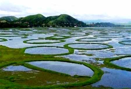
1. Which hemisphere is India located in? = located in the northern and eastern hemispheres. 2. What is the total area of India? = 32,87, 263 square kilometers. m. 3. What is the length of India from north to south? = 3,214 km. 4. What is the maximum width of India from east to west? = 2,933 km. 5. What is the length of India’s coastline? = 7516.6 km. 6. How many states of the Tropic of Cancer pass through India? = 08 from the states (Gujarat, Rajasthan, Madhya Pradesh, Chhattisgarh, Jharkhand, West Bengal, Tripura and Mizoram). 7. Which is the longest coastline state in India? = Gujarat. 8. Which is the oldest port of India? = Lothal Port. 9. Which is the only tidal port of India? = Kolkata Port and Kandla Port. 10. Which is the highest altitude sanctuary of India? = Hemis National Park. 11. Which is the only floating sanctuary in the world? = Keibul Lamjao National Park. 12. What type of soil is found on the highest area of India? = Alluvial soil. 13. Who is called the Pittsburgh of India? = Jamshedpur (Jharkhand). 14. Where is the Konkan coast extended? = Daman from Goa. 15. Where is the area of autumn rain in India? = Punjab and Tamil Nadu. 16. Where is the sandalwood forest found most in India? = Karnataka and Tamil Nadu. 17. Which is the highest peak of the Western Ghats (Sahyadri)? = Anamudi. 18. India has the largest coal reserves? = Jharkhand, Odisha and Chhattisgarh. 19. Which project does not come under the Indo-Nepal Cooperation Project? = Chukka Project. 20. Which is the longest river dam in India? = Hirakud Dam. 21. Wainganga and Panganga are tributaries of = Godavari. 22. Which river is the Kapil Dhara Falls? = on the river Narmada. 23. Which state is the Zojila Pass located in? = Located in the union territory of Ladakh and Jammu & Kashmir. 24. The Indira Gandhi Canal comes out? = It originates from Harike Barrage at the confluence of the Sutlej and Beas rivers in Punjab. 25. The elephant is found in which national park? = Kaziranga National Park, Nagarhole National Park, Kanha National Park and Serengeti National Park. 26. Where does India’s standard timeline pass through? = Passes through Mirzapur city of Uttar Pradesh. 27. What is the length of the international border of India and Bangladesh? = 4,096 km 28. What is the length of the international border with India and China? = 3,488 km 29. What is the length of the international border with India and Afghanistan? = 106 km (lowest). 30. What is the length of the international border with India and Pakistan? = 3,323 km. ======= ============== ===================== भूगोल से संबंधित-182.
1. भारत किस गोलार्ध में स्थित है? = उत्तरी और पूर्वी गोलार्ध में स्थित है. 2. भारत का कुल क्षेत्रफल कितना है? = 32,87,263 वर्ग कि. मी. 3. भारत की उत्तर से दक्षिण तक लंबाई कितनी है? = 3,214 किलोमीटर. 4. भारत की पूर्व से पश्चिम तक अधिकतम चौड़ाई कितनी है? = 2,933 किलोमीटर. 5. भारत की तटीय कितनी लंबाई हैं? = 7516.6 किमी. 6. कर्क रेखा भारत के कितने राज्यों से होकर गुजरती हैं? = 08 राज्यों से (गुजरात, राजस्थान, मध्य प्रदेश, छत्तीसगढ़, झारखंड, पश्चिम बंगाल, त्रिपुरा और मिजोरम). 7. भारत की सर्वाधिक लंबी तटीय सीमा रेखा वाला राज्य कौन सा है? = गुजरात. 8. भारत का सबसे प्राचीन बंदरगाह कौन-सा है? = लोथल बंदरगाह. 9. भारत का एकमात्र ज्वारीय बंदरगाह कौन-सा है? = कोलकाता बंदरगाह और कांडला बंदरगाह. 10. भारत का सर्वाधिक ऊंचाई पर स्थित अभ्यारण कौन-सा है? = हेमिस राष्ट्रीय उद्यान. 11. विश्व का एकमात्र तैरता अभयारण्य कौन-सा है? = किबुल लामजाओ नेशनल पार्क. 12. भारत के सर्वाधिक क्षेत्रफल पर किस प्रकार की मृदा पाई जाती है? = जलोढ़ मिट्टी. 13. भारत का पिट्सबर्ग किसे कहा जाता है? = जमशेदपुर (झारखंड). 14. कोंकण तट कहाँ से कहाँ तक विस्तृत है? = गोवा से दमन. 15. भारत में शरदकालीन वर्षा का क्षेत्र है? = पंजाब व तमिलनाडु. 16. भारत में चन्दन की लकड़ी के वन सबसे अधिक कहाँ पाये जाते हैं? = कर्नाटक और तमिलनाडु. 17. पश्चिमी घाट (सह्याद्रि) की सबसे ऊँची शिखर है? = अनामुडी. 18. भारत में सबसे अधिक कोयले के भण्डार हैं? = झारखंड , ओडिशा और छत्तीसगढ़. 19. कौन-सी परियोजना भारत-नेपाल सहयोग परियोजना के अन्तर्गत नहीं आती है? = चुक्का परियोजना. 20. भारत का सबसे लम्बा नदी बाँध कौन-सा है? = हीराकुड बाँध. 21. वैनगंगा तथा पैनगंगा किसकी सहायक नदी है? = गोदावरी. 22. कपिल धारा जलप्रपात किस नदी पर स्थित है? = नर्मदा नदी पर. 23. जोजिला दर्रा किस राज्य में स्थित है? = लद्दाख और जम्मू-कश्मीर के केंद्र शासित प्रदेश में स्थित है. 24. इन्दिरा गाँधी नहर निकलती है? = पंजाब में सतलुज और व्यास नदियों के संगम पर स्थित हरिके बैराज से निकलती है. 25. हाथी किस राष्ट्रीय उद्यान में पाया जाता है? = काजीरंगा राष्ट्रीय उद्यान, नागरहोल राष्ट्रीय उद्यान, कान्हा राष्ट्रीय उद्यान और सेरेन्गेटी राष्ट्रीय उद्यान. 26. भारत की मानक समय रेखा कहां से होकर गुजरती हैं? = उत्तर प्रदेश के मिर्जापुर शहर से होकर गुजरती है. 27. भारत और बांग्लादेश के अंतर्राष्ट्रीय सीमा की लंबाई है? = 4,096 किलोमीटर. 28. भारत और चीन के साथ अंतर्राष्ट्रीय सीमा की लंबाई है? = 3,488 किलोमीटर. 29. भारत और अफगानिस्तान के साथ अंतर्राष्ट्रीय सीमा की लंबाई है? = 106 किलोमीटर (सबसे कम). 30. भारत और पाकिस्तान के साथ अंतर्राष्ट्रीय सीमा की लंबाई है? = 3,323 किलोमीटर.
|